

DJI Phantom 4 Multispectral
Plant Intelligence for Targeted Action
Gather precise plant-level data using the P4 Multispectral – a high-precision drone with a seamlessly integrated multispectral imaging system built for agriculture missions, environmental monitoring, and more.
Farm to Figures
Gain Immediate Insights into Plant Health. The P4 Multispectral consolidates the process of capturing data that gives insight into crop health and vegetation management. DJI has created this platform with the same powerful performance standards that DJI is known for, including 27 minutes max flight time and up to 7 km1 transmission range with the OcuSync system.

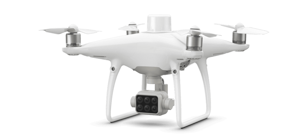
See Beneath the Surface
Agriculture imagery collection is now simpler and more efficient than ever before with a built-in stabilized imaging system that collects comprehensive data sets right out of the box. Access information collected by 1 RGB camera and a multispectral camera array with 5 cameras covering Blue, Green, Red, Red Edge, and Near Infrared bands – all at 2 MP with global shutter, on a 3-axis stabilized gimbal.

Integrated Spectral Sunlight Sensor for Accurate Results
An integrated spectral sunlight sensor on top of the drone captures solar irradiance, which maximizes accuracy and consistency of data collection through different times of day. When combined with post-processed data, this information helps to obtain the most accurate NDVI results.

Meaningful Data at Your Disposal
View Both RGB and NDVI Feeds. Simply having aerial imagery is not enough for ag professionals who want to know more. Switch between a preliminary Normalized Difference Vegetation Index (NDVI) analysis and the live RGB feed to immediately visualize where attention is needed, so targeted treatment decisions can be made quickly.

Centimeter-level Precision
Get real-time, accurate positioning data on images captured by all six cameras with DJI’s TimeSync system, providing centimeter-level accurate measurements. The TimeSync system continually aligns the flight controller, RGB and NB cameras, and RTK module, fixing the positioning data to the center of the CMOS and ensuring each photo uses the most accurate metadata. All cameras go through a rigorous calibration process where radial and tangential lens distortions are measured. The distortion parameters gathered are saved into each image’s metadata, letting post-processing software adjust uniquely for every user.

D-RTK 2 Mobile Station and NTRIP Compatibility
Enhance the accuracy of RTK positioning without internet connection by connecting the P4 Multispectral to the D-RTK 2 High Precision GNSS Mobile Station and NTRIP (Network Transport of RTCM via Internet Protocol), or store the satellite observation data to be used for Post Processed Kinematics (PPK).


Precision agriculture
Throughout all growing seasons, multispectral imagery can be helpful to ag professionals by providing information invisible to the human eye across the electromagnetic spectrum. Having access to this data and the subsequently obtained Vegetation Index data such as NDRE and NDVI, farmers can make timely, informed decisions on crop treatment, lowering costs, saving resources, and maximizing yields.
Environmental monitoring and inspection
Routine inspections and maintenance involving plants can be made smarter and more efficient when using the P4 Multispectral – leverage its actionable multispectral insights to monitor forest health, measure biomass, map shorelines, or manage riparian vegetation while protecting habitats or ecosystems, and much more.
Specifications DJI Phantom 4 Multispectral
| Takeoff Weight | 1487 g |
| Diagonal Distance (Propellers Excluded) | 350 mm |
| Max Service Ceiling Above Sea Level | 6000 m |
| Max Ascent Speed | 6 m/s (automatic flight); 5 m/s (manual control) |
| Max Descent Speed | 3 m/s |
| Max Speed | 31 mph (50 kph) (P-mode); 36 mph (58 kph) (A-mode) |
| Max Flight Time | 27 min |
| Operating Temperature | 0° to 40° C |
| Operating Frequency | 2.4000 GHz to 2.4835 GHz |
| Hover Accuracy Range (with RTK) | Vertical: ± 0.1 m; Horizontal: ± 0.1 m |
| Hover Accuracy Range (without RTK) | Vertical: ± 0.1 m (with vision positioning); ± 0.5 m (with GNSS positioning) Horizontal: ± 0.3 m (with vision positioning); ± 1.5 m (with GNSS positioning) |
| Image Position Compensation | The relative positions of the centers of the six cameras’ CMOS and the phase center of the onboard D-RTK antenna have been calibrated and are recorded in the EXIF data of each image. |
| Single-Frequency High-Sensitivity GNSS | GPS + GLONASS + Galileo |
Camera
| Sensors | Six 1/2.9” CMOS, including one RGB sensor for visible light imaging and five monochrome sensors for multispectral imaging. Each Sensor: Effective pixels 2.08 MP (2.12 MP in total) |
| Filters | Blue (B): 450 nm ± 16 nm; Green (G): 560 nm ± 16 nm; Red (R): 650 nm ± 16 nm; Red edge (RE): 730 nm ± 16 nm; Near-infrared (NIR): 840 nm ± 26 nm |
| Lenses | FOV (Field of View): 62.7° Focal Length: 5.74 mm (35 mm format equivalent: 40 mm), autofocus set at ∞ Aperture: f/2.2 |
| RGB Sensor ISO Range | 200 – 800 |
| Monochrome Sensor Gain | 1-8x |
| Electronic Global Shutter | 1/100 – 1/20000 s (visible light imaging); 1/100 – 1/10000 s (multispectral imaging) |
| Max Image Size | 1600×1300 (4:3.25) |
| Photo Format | JPEG (visible light imaging) + TIFF (multispectral imaging) |
| Supported File Systems | FAT32 (<= 32 GB); exFAT (> 32 GB) |
| Supported SD Cards | microSD with a minimum write speed of 15 MB/s. Max Capacity: 128 GB. Class 10 or UHS-1 rating required |
Price: 6.262,00 €
VAT is included. Price without D-RTK.
D-RTK
HIGH PRECISION GNSS MOBILE STATION
OPTIMIZED ACCURACY.
ULTIMATE RELIABILITY.
D-RTK 2 Mobile Station is DJI’s upgraded high-precision GNSS receiver that supports all major global satellite navigation systems, providing real-time differential corrections that generate centimeter-level positioning data for improved relative accuracy.


Centimeter-Level Positioning
D-RTK 2 Mobile Station fully supports GPS, GLONASS, Beidou, and GALILEO signals. Easy and quick to set up, the D-RTK 2 Mobile Station provides real-time differential data for drones to achieve centimeter-level positioning accuracy. The built-in high-gain antenna offers better signal reception from more satellites even when obstructions are present.

Stay Connected for Any Mission
D-RTK 2 Mobile Station supports communication via 4G, OcuSync, WiFi, and LAN, ensuring uninterrupted, stable data transmission under any application scenario. Up to 5 remote controllers* can be connected to the D-RTK 2 Mobile Station simultaneously when used with DJI Agras drones, the Phantom 4 RTK, or the P4 Multispectral. When used with the Matrice 300 RTK, it can be connected to multiple aircraft, making coordinated operations involving multiple drones a possibility and significantly improving efficiency.

Durability You Can Trust
Featuring IP65 level ingress protection and a lightweight carbon fiber body, the D-RTK 2 Mobile Station is ultra-portable and up for any task, no matter how tough. The built-in IMUs monitor movements and calibrate the tilt sensors to alert the operator of any abnormalities during the mission, minimizing risks.
Specifications D-RTK
| GNSS Frequency | Simultaneously receive: GPS: L1 C/A, L2, L5 BEIDOU: B1, B2, B3 GLONASS: F1, F2 Galileo: E1, E5A, E5B |
| Positioning Accuracy | Horizontal:1 cm+ 1 ppm(RMS) Vertical:2 cm+ 1 ppm(RMS) 1 ppm: For every 1 km increase in distance, the accuracy will be 1 mm less. For example, the horizontal accuracy is 1.1 cm when the receiving end is 1 km away from the base station. |
| Positioning Update Rate | 1 Hz, 2 Hz, 5 Hz, 10 Hz and 20 Hz |
| Initialization Reliability | >99.9% |
| Dimensions(D-RTK 2 body with extension rod) | 168 mm×168 mm×1708 mm |
| IP Rating | IP65 |
| Communication Distance | Operating Mode 1/3 SRRC/NCC/FCC/MIC/KCC/CE: 2 km (Unobstructed and free of interference, when the D-RTK 2 Mobile Station is used as a base station and the distance from the D-RTK 2 antenna to the bottom of the tripod is 1.8 m, when the difference in height between the remote controller and D-RTK 2 is less than 2 m, and when the remote controller is 1.2 m from ground level) Operating Mode 4 Between the aircraft and mobile station: NCC/FCC: 7 km; SRRC/MIC/KCC/CE: 5 km Between the remote controller and mobile station: 200 m (Unobstructed and free of interference at a flying altitude of about 120 m, when the distance from the D-RTK 2 antenna to the bottom of the tripod is 1.8 m, and when the remote controller is 1.2 m from ground level) Operating Mode 5 NCC/FCC: 12 km; SRRC/MIC/KCC/CE: 6 km (Unobstructed and free of interference, when the distance from the D-RTK 2 antenna to the bottom of the tripod is 1.8 m) |
| Operating Temperature | -20° to +55° C |
| Run Time | WB37 battery:>2 h MG-12000P battery:>50 h |
| Power Sources | Internal battery WB37-4920mAh-7.6V External battery (MG12000P) AC power adapter |
Price: Contact with us
VAT is included. P4 Multispectral Price with D-RTK.